2D AND 3D SEISMIC INTERPRETATION
The best way to start to use the Seismic Interpretation in your activities
- Course Type
Classroom Course - Duration
5 days - Thematic
Geosciences - Location
ANYWHERE - Country
-
Satisfaction rate
Why should you attend?
This 2D and 3D Seismic Interpretation training course will focus on reflection seismic, one of the fundamental ways of imaging the subsurface from a geological perspective. 2D and 3D seismic data is a major source of information in the oil industry for both onshore and offshore activities.
Recently this type of data has also been used in geothermal energy activities, carbon sequestration in geological reservoirs and wind energy, especially offshore. Other uses include mapping salt structures for use as natural gas reservoirs (gas caverns), delimiting mineral deposits among other activities involving imaging of the subsurface.
Main Objectives:
The main objective of this course is to prepare geologists, geology engineers and other professionals and students for the use of seismic data in their activity, particularly in the oil industry. Several examples of tools, test data and interpretation techniques will be given that will enable participants to continue their training during and after the course.
During the course and in an organized and systematic manner, we aim to achieve several objectives that are briefly presented:
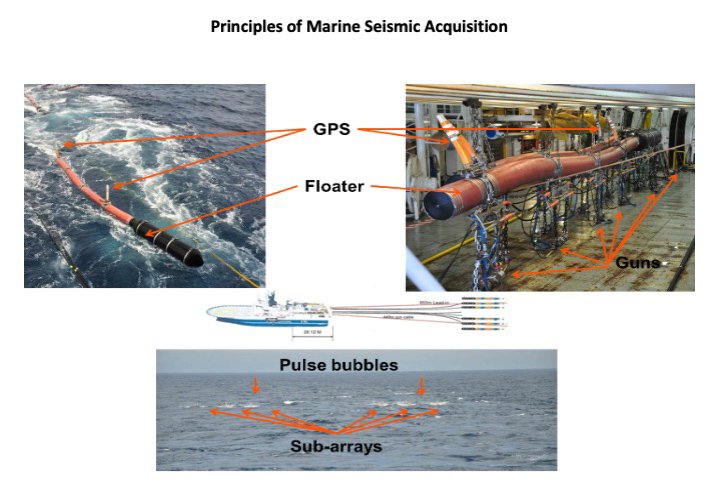
- Understand seismic data acquisition and processing
- Visualize seismic data and develop interpretation capacity
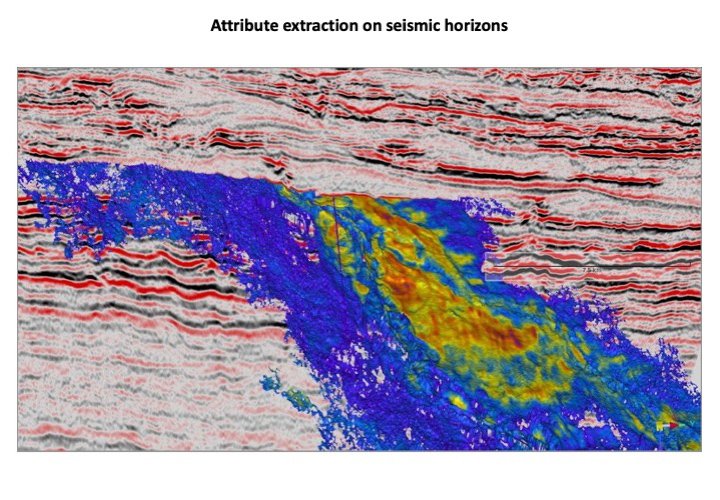
- Interpret and map faults and seismic horizons
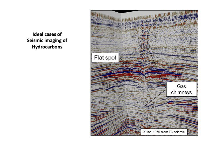
- Identify hydrocarbon accumulations using seismic data
- Quantify and risk hydrocarbon accumulations
Learning Approach:
This training course will utilize a variety of learning techniques to ensure maximum understanding, comprehension, retention of the information presented. The training course includes lectures, videos, case studies, exercises and hands-on practice using a seismic interpretation software and real seismic data. Online Course is available.
HSE requirements:
No specific requirement for this course that can take place in any meeting room with validated HSE characteristics, in your company premises or elsewhere.
Course Agenda:
One week (35-40 hours) is the ideal time. The case can be shortened or lengthened according to the request.
Day 1
1. Introduction
2. History of seismic studies
3. The seismic method
3.1 Rock properties
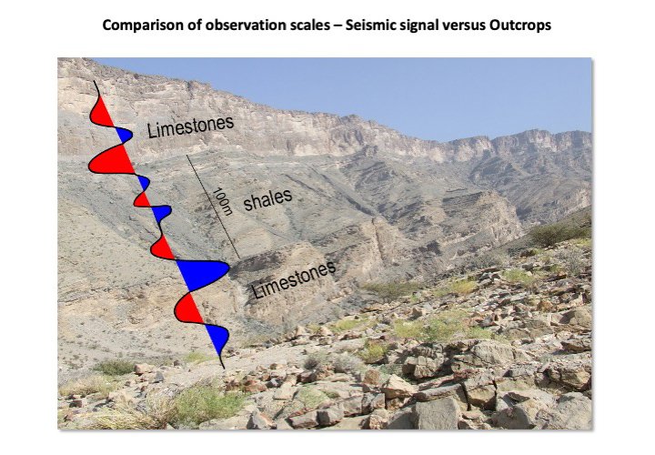
3.2 Wave propagation, reflection, and refraction of seismic waves, reflectivity, impedance
3.3 Data acquisition – Land and Marine
4. Other geophysical methods
4.1 Gravimetry
4.2 Magnetics
4.3 Electro magnetics
5. Seismic data processing overview
5.1 Conventional pre-stack processing and CMP gathers
5.2 Post-stack processing
5.3 Seismic migration, velocity models.
6. Calibration methods (well-tie)
6.1 Velocity surveys
6.2 Sonic logs
6.3 Synthetic seismograms
6.4 Vertical Seismic Profiles
Day 2
1. 2D and 3D Seismic Data
1.1 Parameters, visualization, polarity
1.2 Seismic Data Libraries, public, private and licenses
1.3 Software
2. 2D and 3D interpretation techniques
2.1 hard and soft events
2.2 Vertical exaggeration
2.3 Horizontal and Vertical slicing in 3D data
2.4 Seismic horizons – stratal interface, fluid contacts and non-geological horizons
3. Quantitative interpretation geophysics
3.1 Acoustic impedance and inversion
3.2 AVO and pseudo-gradient
3.3 RMS amplitude
3.4 Spectral decomposition
3.5 Other methods
Day 3
1. Fault interpretation
1.1 Introduction to fault interpretation
2. Structural styles
2.1 Rift basins
2.2 Compressional domains
2.3 Salt tectonics
2.4 Strike-slip faults
3. Mapping faults in 2D data
3.1 Faults in each seismic line
3.2 Connecting faults from different seismic lines
3.3 Building fault planes
4. Mapping faults in 3D data
4.1 Mapping faults in vertical and horizontal slices
4.2 Building fault planes
5. Structural models
5.1 Building a structural model
5.2 Visualization
5.3 Geometry, kinetics, geodynamics
5.4 Palinspastic Reconstructions
Day 4
1. Stratigraphic interpretation
1.1 Horizon interpretation techniques
1.2 Horizon attributes
1.3 Continuity and lateral variations
1.4 Unconformities and stratal terminations
2. Seismic facies
2.1 Carbonate systems seismic facies
2.2 Siliciclastic systems seismic facies
2.3 Gross depositional environments
3. Advanced stratigraphic interpretation
3.1 Wheeler diagrams
3.2 Seismic sequence stratigraphy
Day 5
1. The petroleum system elements and processes
1.1 Reservoir
1.2 Seal
Prerequisites
The course is designed for geophysicists, geologists, geology engineers or students who are interested in gaining or deepening practical knowledge about 2D and 3D seismic interpretation and its uses in the oil industry or other industries where knowledge and visualization of subsurface is important.
Prior knowledge of geology and physics basics will be beneficial to participants. No prior software knowledge is required, but some exercises will be done using OpendTect, a free seismic interpretation software.
Lecturers
-
 Dr. MACHADO G.Gil Machado holds a degree in Geology and a European Doctorate (PhD) in Stratigraphy and Petroleum Geology and has ca. 10 years of experience in the Oil & Gas industry, in exploration projects of Oman, Mozambique, Brazil, Angola, Guinea-Bissau, Senegal, Gabon, Morocco, and other Atlantic basins. He is an advanced seismic interpreter, including sediment fairways identification, deep water sedimentation characterization, sequence stratigraphy and prospect generation and risking. He has worked extensively with well correlation, biostratigraphy, regional prospectivity studies and has managed teams and projects in multiple cultural environments. He has mentored and supervised BSc and MSc students, young professionals and taught several short courses and lectures on these subjects. As part of his career, he worked at Petroleum Development Oman as a Stratigrapher where he was responsible for the Precambrian and Lower Palaeozoic stratigraphy studies and for the scientific management of the palynology laboratory of the company. He followed multiple wells as operational stratigrapher providing real time advice to the well geologists for casing points, TD calls, etc. He also contributed to the biostratigraphic zonation review of the subsurface of Oman. He is affiliated with the European Association of Geoscientists and Engineers, the PESGB and founder and member of the Portuguese Association of Geoscientists and Engineers. Gil Machado is currently heading a geological consulting company - Chronosurveys - providing services and training in Stratigraphy, source rock evaluation, Petroleum Geology.
